
 Norway
  Deutsch
Ryfylke National Scenic Routes
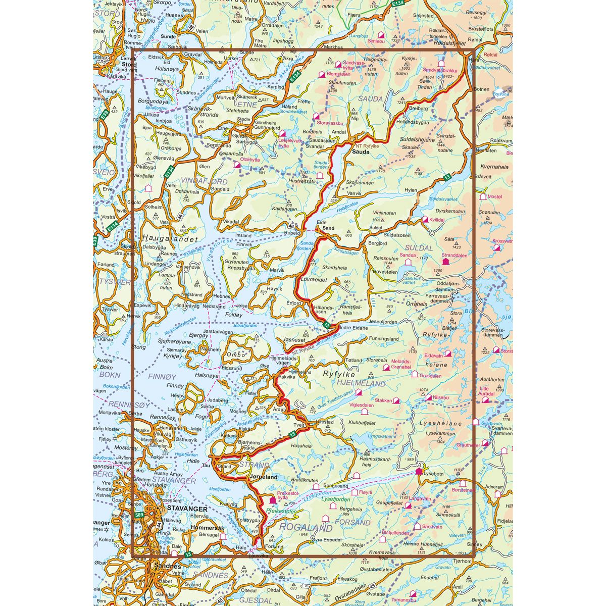
- The map covers Sand, sauda, Stavanger, Jørpeland

| Brand | Nordic Maps |
|---|---|
| SKU | 20002 |
| Map size | 70x100 cm |
| Scale | 1:105 000 |
| Updated | 2014 |
| Material | Paper |
| Map usage | In the car, Sightseeing and activities |
| Accommodation | campsites, hotels |
| EAN | 7046660200025 |
| Map both sides | No |
| Country | Norway |
| Destinations | Sand, sauda, Stavanger, Jørpeland |
| Language | Norwegian, English, German |
| Series | National Scenic Routes |
This route through constantly changing scenery brings you from lush fjords to stark mountains. The drive through the Ryfylke region is a varied one, with small towns and communities interspersed among flourishing farmland and a versatile business and industrial base. Sauda, which is famous for its smelting industry, is situated between mountain peaks and waterfalls innermost in Ryfylke. In Sauda, and in the old zinc mines of the Allmannajuvet gorge, you can experience Norwegian industrial history first hand. The trip across the Sauda mountains into the Røldal valley is spectacular, along a road that snakes through the towering mountain landscape. Some of Norways most well-known attractions, such as the Prekestolen cliff and plateau (Pulpit Rock), the Lysefjord and the wedged boulder called Kjæragbolten, can be explored on short detours from the route. National Tourist Route Ryfylke runs from Oanes on the Lysefjord, via Sauda to Hordalia in the Røldal valley over a total distance of 183 kilometres (National Road 13, County Road 46/520). The route includes two ferries that offer you a different perspective on the fjord scenery. The stretch from Helandsbygd to Røldal is closed in the winter season. This road usually closes in November and reopens in June.
This map series will enable some wonderful experiences along the selected routes.
The maps indicate spectacular views, nature experiences, attractions, architecture, dining spots, overnight accommodations and places of interest. These are described in the map with text and photos.
The maps have been designed in cooperation with the Norwegian Public Roads Administration.
The products are available in
three languages - Norwegian, English and German.